| No. of Pages | 1 |
|---|---|
| Download Size | 84 KB |
| Category | General |
Andhra Pradesh Map - Preview
 Read Online / Preview
Andhra Pradesh Map - Summary
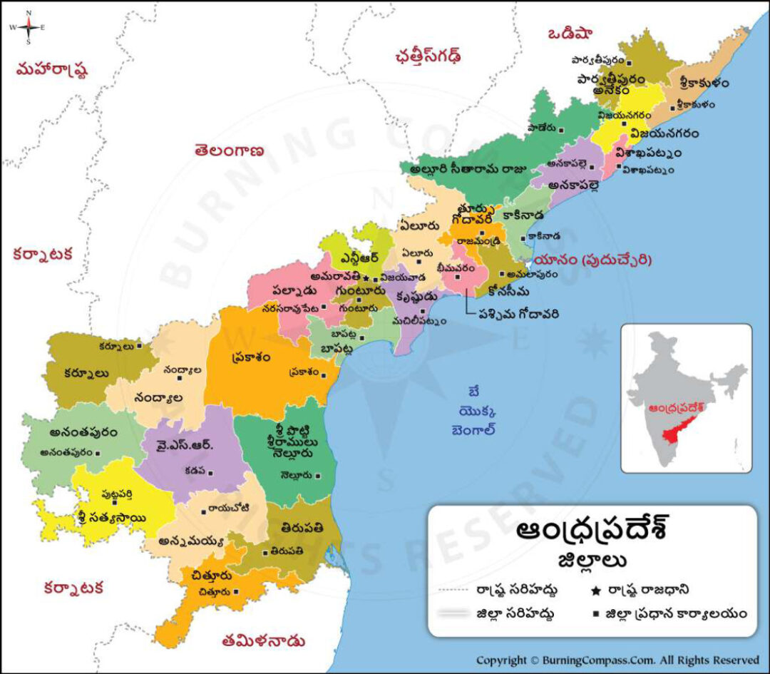
Andhra Pradesh Map Telugu PDF can be downloaded from the link given at the bottom of this page. Andhra Pradesh state is located on the southeastern coast of the country. AP State capital is Hyderabad.
Andhra Pradesh Political Map showing the 26 districts, district headquarters, and capital of Andhra Pradesh state in India. It is bounded by the Indian states of Tamil Nadu to the south, Karnataka to the southwest and west, Telangana to the northwest and north, and Odisha to the northeast. The eastern boundary is a 600-mile (970-km) coastline along the Bay of Bengal.
Andhra Pradesh Political Map Telugu
| S. No | District Name | Headquarters |
|---|---|---|
| 1 | Srikakulam | Srikakulam |
| 2 | Vizianagaram | Vizianagaram |
| 3 | Manyam District – Parvathipuram (new) | Parvathipuram (new) |
| 4 | Alluri Sitaram Raju District – Paderu (new) | Paderu (new) |
| 5 | Visakhapatnam | Visakhapatnam |
| 6 | Anakapalli – Anakapalli (new) | Anakapalli (new) |
| 7 | Kakinada – Kakinada (new) | Kakinada (new) |
| 8 | Kona Seema – Amalapuram (new) | Amalapuram (new) |
| 9 | East Godavari | Rajamahendravaram |
| 10 | West Godavari | Bheemavaram |
| 11 | Eluru – Eluru (new) | Eluru (new) |
| 12 | Krishna | Machilipatnam |
| 13 | NTR District – Vijayawada (new) | Vijayawada (new) |
| 14 | Guntur | Guntur |
| 15 | Bapatla – Bapatla (new) | Bapatla (new) |
| 16 | Palnadu – Narsaraopeta (new) | Narsaraopeta (new) |
| 17 | Prakasam | Ongole |
| 18 | SPS Nellore | Nellore |
| 19 | Kurnool | Kurnool |
| 20 | Nandyal – Nandyal (new) | Nandyal (new) |
| 21 | Ananthapuram | Ananthapuram |
| 22 | Sri Satyasai District – Puttaparthy (new) | Puttaparthy (new) |
| 23 | YSR Kadapa | Kadapa |
| 24 | Annamayya District – Rayachoty (new) | Rayachoty (new) |
| 25 | Chittoor | Chittoor |
| 26 | Sri Balaji Dist. – Tirupati (new) | Tirupati (new) |